Defining Rural
Geographic Terms
And Concepts
Establishing a definition of rural poses many challenges. Rural areas share the common characteristics of comparatively few people living in an area, proximity to large cities, and considerable traveling distances to market areas for employment and everyday living activities. Over the years, public agencies and researchers have used combinations of these factors to define rural areas and designate population as rural.
Some of the more commonly used definitions to designate rural areas are promulgated by government organizations such as the Office of Management and Budget (OMB), the Census Bureau, and other federal agencies. These classifications, however, are far from synonymous or mutually exclusive concepts. For example, after the 2013 OMB Metropolitan Areas reclassification, it is estimated that approximately 56 percent of the census-defined rural population now lives in metropolitan areas. Such incongruities illustrate the complexity of relying on individual definitions for research and programmatic purposes.
Political and economic geography is another important consideration when determining the rurality of an area. The county is a commonly used unit of geography from which to classify rural or outside metropolitan areas. In many rural areas, the county is often identified in terms of political, social, and economic contexts. However, county-based designations are not the optimum criteria on which to base a rural definition. Large counties, particularly in the Western United States, may dilute or mask rural population given their geographic size and influence.
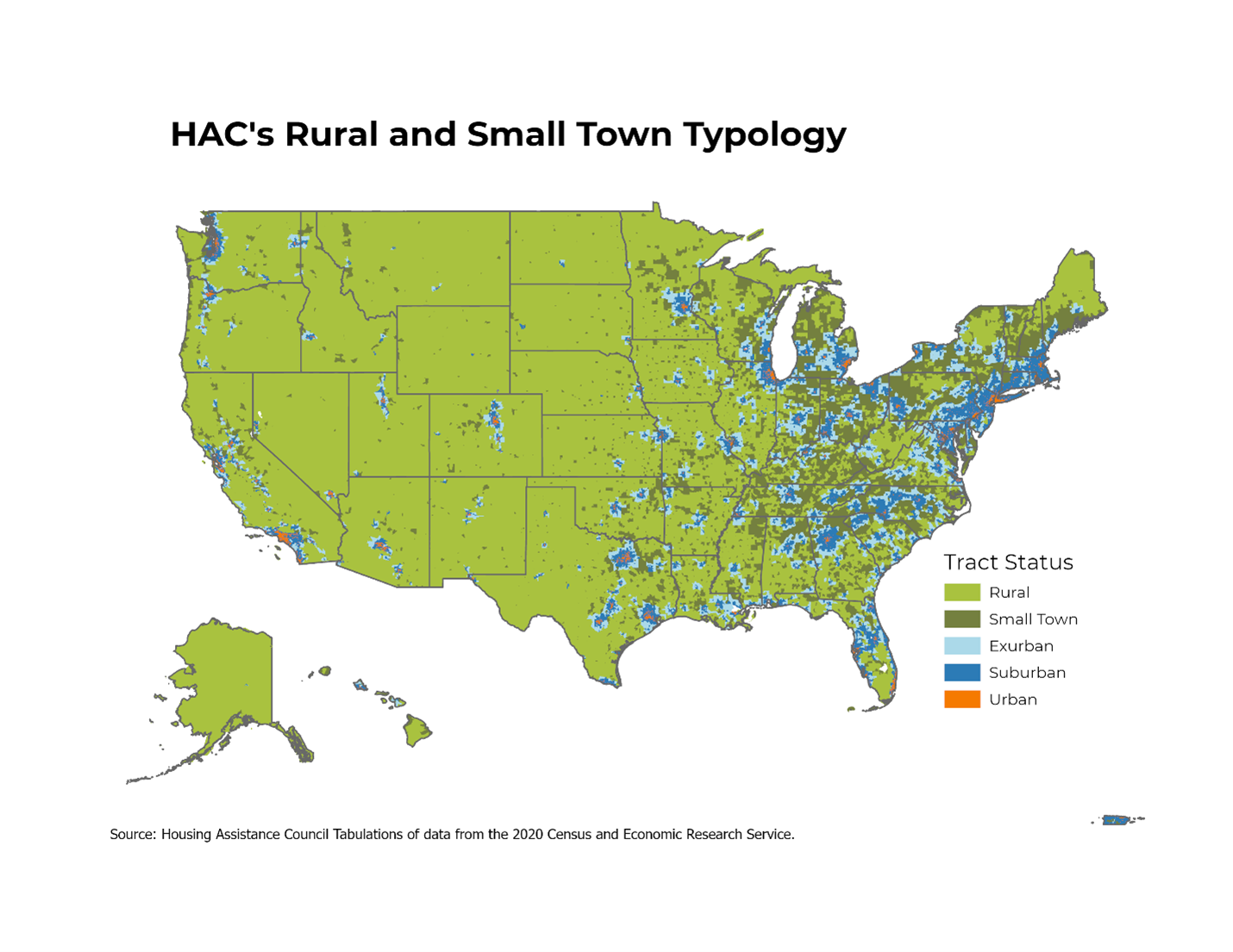
HAC’s Rural & Small Town Tract Designation
Given the changes and shortcomings to traditional definitions used to identify rural geography and populations, HAC developed a sub-county designation of rural and small-town areas which incorporates measures of housing density, commuting, and contiguity at the census tract level to establish a more precise measure of rural character. This alternative residence definition includes six classifications: 1) rural, 2) small-town, 3) exurban, 4) outer suburban, 5) inner suburban, and 6) urban.
The HAC rural tract classifications are specifically defined by the following characteristics.
1 = Rural tract
Less than 16 housing units per square mile (.025 housing units per acre).
2 = Small-town tract
Sixteen to 64 housing units per square mile (.025 to 0.1 housing units per acre), and a low degree of commuting to a metropolitan core area identified by a USDA ERS designated “Rural Urban Commuting Area Code” (RUCA) score of 4 or higher.
3 = Exurban tract
Sixteen to 64 units per square mile (.025 to 0.1 housing units per acre) and a high degree of commuting to a metropolitan core area identified by a RUCA score of 3 or lower.
4 = Outer Suburban tract
65 to 640 housing units per square mile (0.1 to 1.0 housing units per acre).
5 = Inner Suburban tract
641 to 1,600 housing units per square mile (1.1 to 2.5 housing units per acre).
6 = Urban tract
More than 1,600 housing units per square mile (2.5 housing units per acre).
In addition to these factors, HAC implements additional adjustment and refinement techniques using GIS technology and visual review to identify and correct for geographic and development anomalies and create classifications with greater contiguity.
For simplicity, these designations are often collapsed into three general classifications of: 1) small town and rural tracts, 2) suburban and exurban tracts, and 3) urban tracts.
USDA Economic Research Service Rural-Urban Commuting Area Codes 3
The Rural-Urban Commuting Area (RUCA) codes are a detailed and flexible scheme for delineating sub-county components of the U.S. settlement system developed by the U.S. Department of Agriculture’s Economic Research Service (ERS). RUCA codes are based on the same theoretical concepts used by the Office of Management and Budget to define county-level metropolitan and micropolitan areas. ERS applied similar criteria to measures of population density, urbanization, and daily commuting to identify urban cores and adjacent territory that is economically integrated with those cores. ERS adopted OMB’s metropolitan and micropolitan terminology to highlight the underlying connectedness between the two classification systems. However, the use of census tracts instead of counties as building blocks for RUCA codes provides a different and more detailed geographic pattern of settlement classification. Census tracts are used because they are the smallest geographic building blocks for which reliable commuting data is available.
OMB Metropolitan Areas 4
The Office of Management and Budget (OMB), beginning in 1949, has classified counties based on their proximity to, and connection with, core-based urban areas. Each metropolitan area (MA) has at least one urbanized area of at least 50,000 people. Based on share of population residing in urbanized areas and commuting patterns, counties are then defined as being either in a MA or not. As a result, each MA consists of counties that have either a large share of their population in the urbanized core(s) and/or a relatively large share of their population commuting to the urbanized core(s). Counties that are outside MAs are often considered rural, although the OMB definition specifically states this is not their description of these areas. There are additional OMB geographic classifications such as micropolitan statistical areas and core based statistical areas; however, these are not used in Rural Data Central.6
For more information of accuracy of data from the American Community Survey please consult the Census Bureau publication, ACS Design and Methodology: http://www.census.gov/acs/www/methodology/methodology_main/.
NOTES
1 U.S. Census Bureau, “Defining ‘Rural’ Areas,” accessed August 22, 2022,
https://www.census.gov/content/dam/Census/library/publications/2019/acs/ACS_rural_handbook_2019_ch01.pdf.
2 HAC’s tract-based rural classification definition is based in part on concepts of housing density introduced by David Theobald, “Land-Use Dynamics Beyond the American Urban Fringe,” Geographical Review 91, no. 3 (July 9, 2001), pp. 544-564.
3 “Rural-Urban Commuting Area Codes,” USDA Economic Research Service, August 17, 2020
http://www.ers.usda.gov/data-products/rural-urban-commuting-area-codes.aspx
4 The OMB’s designation of metropolitan statistical areas is updated regularly to capture small year-to-year changes, but OMB engages in a large-scale update once new decennial Census data is made available. This general revision takes several years, due to the consideration of commuting patterns and the data needed to make that assessment. For example, OMB made its large-scale update for 2010 in 2013.
5 Anthony F. Pipa and Natalie Geismar, “The New Rural? The Implications of OMB’s Proposal to Redefine Metropolitan Areas,” March 18, 2021,
https://www.brookings.edu/research/the-new-rural-the-implications-of-ombs-proposal-to-redefine-nonmetro-america/.
6 “Metropolitan and Micropolitan: About,” U.S. Census Bureau, November 22, 2021,
https://www.census.gov/programs-surveys/metro-micro/about.html.